
 LOWA Renegade EVO GTX MidGORE-TEX, 3 widths, resolableCheck price on Amazon →
 Hydro Flask Wide Mouth 32ozinsulated, durableCheck price on Amazon →
 Osprey Talon 22ventilated back, pole carryCheck price on Amazon →
 Adventure Medical Kits Ultralight Watertight .7day-hike specific, waterproofCheck price on Amazon →
 Black Diamond Spot 400-Rrechargeable, comfortableCheck price on Amazon →
The Pinnacle at a glance: A 9-mile Appalachian Trail loop near Hamburg that climbs past two clifftop overlooks and ends at what many hikers call the best view in Pennsylvania. Go counterclockwise so the rocky climbing comes early and a smooth old fire road carries you back down. The footing is classic Pennsylvania AT rock most of the way up, so wear real boots, and give any rattlesnake sunning itself a wide berth in summer. The lot fills by mid-morning on nice weekends.
Ask hikers to name the best view on Pennsylvania’s stretch of the Appalachian Trail and the answer comes back the same almost every time: the Pinnacle. This 9.3-mile loop from the Hamburg Reservoir trailhead earns that reputation twice over, because the route serves up two rewarding overlooks — Pulpit Rock at the top of the climb and the Pinnacle itself a couple of miles farther along the ridge. Thousands of hikers rate the loop near-perfect, and the ones who grumble mostly grumble about the same thing: the rocks.
Hiked counterclockwise, the loop starts gently on a gravel road past the Hamburg Reservoir before the white-blazed AT takes over and the real work begins. The climb to Pulpit Rock packs in most of the day’s roughly 1,300 feet of gain, and it does so over the bouldery, ankle-testing rock that Pennsylvania’s section of the AT is famous for. Pulpit Rock arrives near the 2-mile mark with a broad view over the valley, and a small astronomical observatory sits improbably beside the overlook — a favorite oddity that hikers mention again and again.
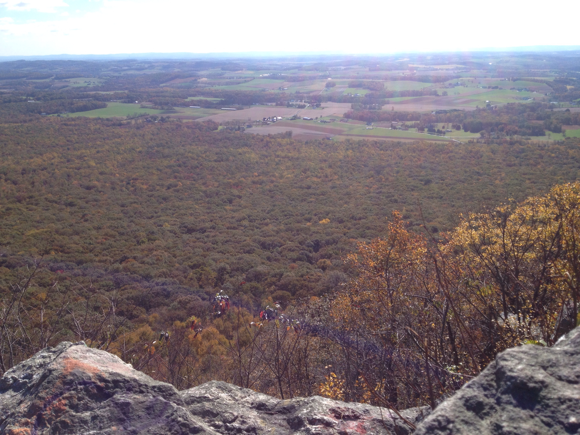
From Pulpit Rock the trail runs about two more miles along the Kittatinny Ridge to the Pinnacle. The ridge walk is still rocky underfoot but far gentler than the climb, and the payoff at the end is the main event: open cliff ledges looking out over a patchwork of Berks County farmland, with the Blue Rocks boulder run visible in the woods below and hawks working the thermals off the ridge. An enormous rock cairn marks the short spur to the overlook, and tradition says first-time visitors should add a stone to it. The ledges have room to spread out, which is good, because nearly everyone stops here for a long lunch.
The return leg is the reward for all that rock. From the Pinnacle the loop descends on a wide old fire road with smooth, easy walking that lets your legs and your attention recover. Closer to the reservoir a blue-blazed valley rim path offers a quieter wooded alternative for the final stretch. After four miles of watching every foot placement on the way up, the cruise back down is genuinely pleasant rather than an afterthought.
Moderate is the consensus, with the caveat that the difficulty lives in the footing rather than the steepness. The grade is never extreme, and there is no required hands-on scrambling unless you go looking for it around the outcrops. What makes the loop earn its rating is nine-plus miles of distance combined with relentless rock through the first half. Most hikers finish in about four hours; plan for longer if the rocks slow you down or the overlooks hold you hostage.
Sturdy boots with ankle support make a bigger difference here than on almost any other hike in the region, and trekking poles pay for themselves on the rocky sections. Hikers comfortable with a 9-mile day will find the Pinnacle demanding but fair. Anyone whose longest hike so far is a smooth 4-miler should treat this as a step up and budget accordingly.
Spring and fall are the sweet spots. Fall pairs the farmland views with foliage across the ridge and valley, and crisp air keeps the climb comfortable. Spring brings green woods and reliable flow in the streams near the reservoir. Clear, dry days matter more here than the season, since haze flattens the long views and wet rock turns the descent from Pulpit tedious.
Summer works, with two warnings. Heat builds on the exposed ledges, and timber rattlesnakes sun themselves on the rocks around both overlooks in warm months — sightings are routine, and the snakes want nothing to do with you, so give them space and move on. Winter is doable for experienced hikers, but ice lingers on the rocky sections and traction gear is smart from December through March.
The trailhead is the Hamburg Reservoir parking area off Reservoir Road, about ten minutes outside Hamburg and roughly 90 minutes from Philadelphia. Parking is free, but the mid-sized lot fills by 8:30 on fair-weather weekends and overflow ends up strung along the road, so an early start solves both the parking problem and the crowding at the overlooks. There are no dependable facilities at the trailhead, and the nearest services are back in Hamburg.
Carry more water than the mileage suggests. The ridge is dry once you leave the reservoir area, and the rocky climbing takes more out of you than the elevation numbers imply. Cell service on the ridge is intermittent. The route follows white AT blazes with blue-blazed connectors, and junctions are signed well enough that the loop is easy to follow in either direction.
Dogs are allowed on leash, and plenty make the loop, though the sharp rock is hard on paws over nine miles. Hawk Mountain Sanctuary sits on the same ridge a short drive away, which makes it easy to pair a morning on the loop with an afternoon of hawk watching in migration season.
The Pinnacle carries a 4.7 rating from nearly 4,900 hikers, with five-star reviews far outnumbering everything else. The praise centers on the two overlooks and the satisfying shape of the loop — hard work first, big views in the middle, easy miles home. The recurring advice is remarkably consistent: go counterclockwise, arrive early, wear boots rather than sneakers, and do not underestimate the rocks.
The complaints are few and predictable. Bluebird weekends draw real crowds to the ledges, the rocky miles wear on people who came expecting a stroll, and summer snake sightings startle the unprepared. None of that dents the consensus. For a day hike within striking distance of Philadelphia and Allentown, this loop remains the standard the others get measured against.
LOWA Renegade EVO GTX MidGORE-TEX, 3 widths, resolableCheck price on Amazon →Hydro Flask Wide Mouth 32ozinsulated, durableCheck price on Amazon →Osprey Talon 22ventilated back, pole carryCheck price on Amazon →Adventure Medical Kits Ultralight Watertight .7day-hike specific, waterproofCheck price on Amazon →Black Diamond Spot 400-Rrechargeable, comfortableCheck price on Amazon → Patagonia Torrentshell 3L Jacketdurable, trail + everydayCheck price on Amazon →
 Darn Tough Hiker Micro Crew Midweightlifetime warrantyCheck price on Amazon →
 Black Diamond Pursuit Trekking Polescork grip, lightweightCheck price on Amazon →
 Sawyer Squeeze Water Filterultralight, standard threadsCheck price on Amazon →
 Sawyer Premium Permethrin Insect Repellent Spraytreat clothing; kills ticksCheck price on Amazon →
 Mountain Hardwear Crater Lake Long Sleeve HoodyUPF 50, hood + thumb holesCheck price on Amazon →


_(9290295228).jpg?width=800)